
Walk #20
15 December 2004
2:59 pm to 3:59 pm
Heads: 40
Tails: 41
Intersections: 56
Ending point: corner of Fulton Street and Cliff Street
Latitude/longitude: 40:42:29.934N/74:00:17.323W
Distance from home: 0.1672 miles
Literature received: none
Coin: 2001 P quarter (North Carolina)
I was curious as to how one of my walks would look like if the route were rendered on a map. This was the result:
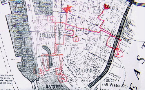
The star was my home (where I started); the dot was where I ended up. (The numbers are there to help you keep the path straight.) I decided that every fifth walk, instead of writing an essay about what happened, I would make a map.